×


We have detected your country as:
Please click here to go to the USA website or select another country from the dropdown list.
by: Terry Mason, Director of International Development
Have you ever longed to take on an epic quest? Perhaps visiting the Land of Israel on a tour would fulfill such a pursuit for you. But there are also those who long to experience the Land in a more intimate and epic way. For those people—both Israelis and visitors alike—only hiking the Israel National Trail (INT) will suffice.
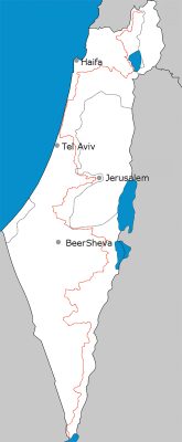
 In Hebrew, the INT is called Shvil Yisrael. It runs the entire length of Israel, from the Lebanese border in the north to Eilat and the Gulf of Aqaba on the Red Sea in the south. Although Israel is only around 290 miles (470 km.) long, the INT stretches over approximately 683 miles (1,100 km.).
There are over 9,320 miles (15,000 km.) of well-maintained and marked hiking trails in Israel, but the INT is the Holy Grail. In fact, National Geographic named it as one of the 20 most epic hiking trails in the world. Young Israelis may hike the trail to get in shape just before joining the Israel Defense Force for their compulsory service. For others, it is a way to celebrate major life events, such as a bar or bat mitzvah (religious coming-of-age ceremony), getting married or milestone birthdays. Regardless, it is a badge of honor to complete this impressive journey.
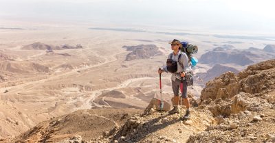
The INT traverses a wide diversity of habitats and landscapes, from stark, barren desert to forested mountains with waterfalls. However, the diversity encountered on the INT is not limited to habitat and geography. The rich assortment of flora and fauna that hikers can marvel at varies depending on the season. Another surprise to some hikers is the richness of both ancient and modern cultures along the trail. Hikers also have the opportunity to enjoy the rich history of this Land. At nearly every turn, there are remnants of Roman, Byzantine, Ottoman and British civilization. In one spot on the trail near Modi’in, hikers can stop at a 1,800-year-old rest stop when they need a break. The ancient stop has a mosaic depicting anemones (kalaniot), which still grow wild on the hillside each spring.
As is true for any epic quest, the INT takes planning and preparation. Only four out of every 10 people who begin the hike actually complete it. On average, a through-hike takes between 45 to 60 days to complete. One can hike the INT in either direction, from north to south or south to north. Many people prefer to tackle the INT in smaller sections over the course of several years. And in the desolate Negev region, it is necessary to cache water supplies ahead of time as there are no natural water sources to draw from.
The INT is clearly marked with three striped trail markers, combining blue, white and orange. On any given day, hikers may follow dirt roads, camel paths or narrow ledges along canyons with iron handholds bolted into the wall. The elevation gains and steep descents pose a true challenge, but the expansive views from many parts of the trail make all the effort more than worth it.

The brainchild of avid hikers Avraham Tamir and Ori Dvir, the INT was officially inaugurated in 1994 by then Israeli President Ezer Weizmann to offer adventurers a way to experience the length and breadth of the Land firsthand. Tamir hiked the famed Appalachian Trail in the US in the late 1970s, where the idea for something similar in Israel was born. Dvir was one of the original founders of the Society for the Protection of Nature in Israel.
Originally, existing sections of current trails were combined to make up the INT. Then some new sections were added to complete the full length. Today, it is divided into 53 sections with designated camping sites between each. The trail planners ensured that the route only traverses areas generally considered under Israeli sovereignty. As such, the INT does not pass through Judea, Samaria or the Golan Heights. It winds through the Negev Desert, the central hill country near Jerusalem, the coastal plain and the northern Galilee. In the desert areas of the south in particular, the trail diverts around extensive army training areas.
“Trail Angels” are a unique part of hiking the INT. Since the trail runs through the Holy Land, you may think that this phrase refers to actual angelic beings. But Trail Angels are mere mortals with big hearts and helpful dispositions who provide practical assistance to those doing a through-hike. And after a grueling day in the dust and heat, these caring individuals seem like angels. There are over 120 officially registered Trail Angels. Most live in close proximity to the trail in small towns and villages along the way. The assistance they provide is often free and varies from a lean-to in the backyard with a hot shower and toilet to a full guest room and a hot breakfast in the morning. Trail Angels come from all sectors of Israeli society and add to the joy of experiencing Israel up close and personal during this epic adventure.
Many sections of the INT can be completed in one day. Some are spectacularly beautiful, offering places to cool off in springs or streams along the way. Next time you are in Israel, why not look for those blue, white and orange trail markers and get to know the Land in a more intimate way…off the well-beaten tourist track on the Israel National Trail.
Photo Credit: Click on photo to see photo credit
Photo License: Israel National Trail
All logos and trademarks in this site are property of their respective owner. All other materials are property of Bridges for Peace. Copyright © 2024.
Website Site Design by J-Town Internet Services Ltd. - Based in Jerusalem and Serving the World.